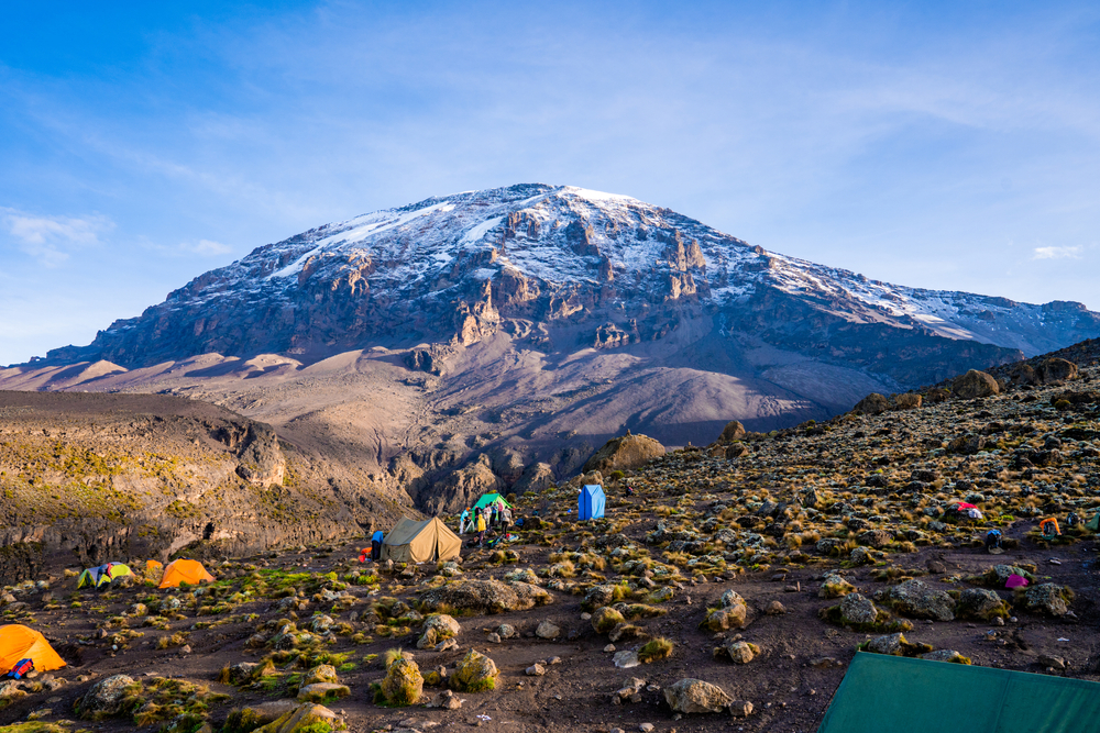
Situated in Tanzania, Mount Kilimanjaro is Africa’s highest peak, reaching approximately 5,895 meters (19,340 feet). It is the highest free-standing mountain in the world. Kilimanjaro is classified as a stratovolcano, a giant volcano composed of ash, lava, and rock. It consists of three volcanic cones: Kibo, Mawenzi, and Shira. Kibo is the highest point and the main summit of the mountain. While Mawenzi and Shira are considered extinct, Kibo remains dormant with the potential to erupt again. It is estimated that Kibo last erupted around 360,000 years ago. Kilimanjaro is famous for its snow-capped summit, but there are concerns that the snow cover could vanish in the next 20 years due to climatic changes.
Please note that it is not permitted to climb Kilimanjaro without a licensed guide unless special authorization is obtained. Guides will not only ensure your safety, but they will also help you carry gear, prepare food, and set up camp. The cost of hiring a guide will vary depending on the size of your group and the length of your climb. However, you can generally expect to pay between $2,000 and $6,000 for guide services. Read this article to learn more about booking your guided Kilimanjaro trek.
Kilimanjaro Weather
Mount Kilimanjaro experiences two primary rainy seasons: one from March to May and a shorter one in November. The mountain’s northern slopes receive significantly less rainfall compared to the southern slopes. At the summit, the average temperature is around −7 °C (19 °F). On the Northern Ice Field, nighttime surface temperatures typically drop to −9 °C (16 °F), with daytime highs averaging −4 °C (25 °F). During periods of extreme radiational cooling, temperatures on the Northern Ice Field can lower to between −15 and −27 °C (5 to −17 °F).
Snowfall is possible throughout the year but primarily occurs during the two rainy seasons of northern Tanzania. At the summit, most of the precipitation falls as snow and graupel, accumulating between 250 to 500 mm (9.8 to 19.7 inches) annually. This snow typically melts away within a few days to years, depending on conditions.
Trekking Routes
Mount Kilimanjaro features seven official trekking routes for ascending and descending: Lemosho, Lemosho Western-Breach, Machame, Marangu, Mweka, Rongai, Shira, and Umbwe.
Machame Route
Machame route, often called the “Whiskey” route, is particularly popular. According to Kilimanjaro National Park statistics, approximately 35% of all climbers choose this six- or seven-day camping route. The trail is favored for its beautiful views, the challenge it presents, and ample opportunities for acclimatization, making it an ideal choice for those who can allocate more time to climb.
Machame is more demanding than the “Coca-Cola” route, known officially as the Marangu route, where sleeping in huts is the norm. In contrast, the Machame route offers a camping experience, requiring trekkers to sleep in tents throughout their journey to the summit.
The itinerary spans either 6 or 7 days, with the route being well-suited for both seasoned hikers and novice backpackers due to its “climb high, sleep low” approach. The 6-day option has a success rate of around 73%, while extending the trek to 7 days increases the success rate to over 85%, providing better acclimatization and increasing the likelihood of reaching the summit successfully.
Here’s a detailed itinerary of the Machame route for climbing Mount Kilimanjaro:
Day 1: Machame Hut Camp
The adventure begins with a short drive to the Machame trailhead, approximately 5,380 feet above sea level. It takes around 50 minutes to drive from Moshi to the Machame Gate. The route passes through the village of Machame on the mountain’s lower slopes. From the park gate, the trail ascends through a dense rainforest on a winding path up a ridge leading to the Machame Camp.
Day 2: Shira Plateau
Exiting the rainforest glades, the path steepens as it ascends to a rocky ridge. Reaching the Shira Plateau involves passing through heather and open moorlands, crossing a large river gorge, and finally camping at Shira 2 Camp.
Day 3: Barranco Camp
The trail continues eastward up a ridge, then southeast towards the Lava Tower, a prominent 300-foot tall volcanic rock formation. Afterward, you descend to Barranco Camp through the unique Senecio Forest, reaching an altitude of 13,000 feet. Though the start and end elevations are the same, the day’s higher altitude trek is crucial for acclimatization.
Day 4: Karanga Camp
The day starts with a descent into a ravine to the base of the Great Barranco Wall. You then face a steep, non-technical climb nearly 900 feet up the cliff. Upon surmounting the Barranco Wall, traverse several hills and valleys before a sharp descent into Karanga Valley. A final steep ascent leads to Karanga Camp. This shorter day helps with acclimatization.
Day 5: Barafu Camp
Leaving Karanga, the trail intersects with the Mweka Trail and continues up a rocky path to Barafu Hut. You will enjoy various summit views by completing the Southern Circuit at this stage. Camp is made at Barafu, where you rest and have an early dinner in preparation for the summit attempt.
Day 6: Summit and Mweka Camp
The summit push begins around midnight, marking the most challenging part of the trek due to extreme cold and wind. The ascent is slow, with frequent short breaks. Near Stella Point (18,900 ft), a spectacular sunrise over Mawenzi Peak awaits. The climb culminates at Uhuru Peak, the highest point in Africa. The descent then follows to Mweka Hut campsite, with a lunch stop at Barafu. The trail down can be tough on the knees; trekking poles are recommended. Mweka Camp, located in the upper forest, often experiences mist or rain by late afternoon. You enjoy your last dinner on the mountain and a well-deserved sleep here.
Day 7: Mweka Park Gate (~5,000′) to Arusha
On the final day, you descend to Mweka Gate to collect summit certificates. The lower trail can be wet and muddy. After reaching Mweka Village, a vehicle will transport you back to your hotel in Moshi, marking the end of your mountain journey.
The Essentials of Climbing Mount Kilimanjaro
Weather: A choice to climb Kilimanjaro is between the end of December and the end of February, just after the rainy season and before the hot, dry season. Weather can be variable and change quickly throughout the day, so it’s important to be well-prepared for all conditions.
Language: Trekking agencies typically assign guides who can communicate in the client’s language, with most speaking English fluently. This helps ensure clear communication throughout the journey.
Tipping: Tipping is an important aspect of the trekking experience, as guides and porters rely significantly on tips for their livelihood. Porters typically earn between $5 and $10 daily, while guides earn more than $10 daily. It’s common for them to expect tips to approximately double their daily wage.
Currency: US dollars and euros are accepted, making transactions convenient for most international travelers.
Water: There are no direct drinking water sources along the route, but the mountain features numerous streams and springs. Water drawn from these sources must be boiled or sterilized with tablets. Water between Karanga Camp and Barafu Camp is unavailable, and climbers should plan accordingly. Carrying biodegradable wipes is recommended for hygiene, as showers are not an option. Also, plastic bottles are prohibited on the climb.
Food: Guides and porters prepare food according to climbers’ dietary preferences. Fresh fruits are often included to provide extra hydration.
Hydration: Climbers are advised to drink at least 4 liters of water daily to adjust to the altitude changes. Although consuming this amount can be challenging, it is crucial for preventing altitude sickness.
The key to climbing Kilimanjaro: is ascending slowly. Gradually increasing elevation is crucial for allowing the body to adjust to lower oxygen levels when climbing Mount Kilimanjaro. The length of the trip plays a pivotal role in a successful summit attempt, primarily because the most common reason for failure is altitude sickness rather than physical exhaustion. Effective acclimatization significantly enhances the likelihood of reaching the summit. Those who acclimatize adequately are more likely to succeed, while those who do not are unlikely to reach the top. That’s why it’s important to choose a climbing route and itinerary that provide ample time for gradual adaptation to altitude changes.
Insects: While insects are not generally a problem, mosquitoes can be present during the first and last days while passing through the rainforest. It is advisable to bring insect repellent and something to alleviate itching after bites.
Good sources for planning your journey: Source 1 | Source 2 | Source 3
If you have already summitted Kilimanjaro, we would be happy to create a guide based on your experiences on the mountain. Please get in touch with us by sending a message to any of our social media accounts below.
With MapMagic route planner, you can craft your one-of-a-kind adventure with friends, add segments and multiple routes on one map, and use 70+ maps and layers to fully prepare for navigating unknown terrain. Join here